Green Valley Campground - Lake Cuyamaca S.P.
Of all destinations in Southern California, Lake Cuyamaca State Park is far and away our favorite. The combination of the beautiful mountain scenery, the water falls at Green Valley, the miles upon miles of hiking trails, and the proximity to the iconic town of Julian all combine to make Cuyamaca one of the best all around weekend destinations. Only an hour away from San Diego and two hours away from Orange County, you owe it to yourself to make the trip to enjoy the park.
This post is about my experience at Green Vally Campground, the smaller and southernmost of the two campgrounds within the park. You can read about the larger campsite, Piso Picacho, here.
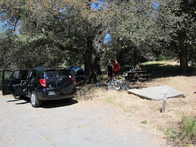
The Green Valley campground is mainly popular for the creek and water falls within the campsite, but the camping itself can't be overlooked. There are 81 campsites, almost all shaded by big beautiful oak trees and defined by granite boulders. The terrain and trees do give a sense of privacy to most of the sites, but as always, sound does carry, although compared to most other campsites Green Valley can be considered to be very separated. Our site, #60, might have been the best site in the entire campground, as we were surrounded on all sides by trees and were never bothered (see picture below).
 |
| Campground #60 - Best Site in the Campground |
Sites 1-15 are located in the equestrian campground. To reserve a spot in the Green Valley Family Horse Camp, call 1-800-444-7275. The Los Vaqueros Group Campground is open from May to November, and is $550 per night for up to 80 people. Green Valley also contains the trailhead to the Arroyo Seco Primitive Trail Camp, as well as the Arroyo Seco Picnic Area. The Pine Ridge trailhead originates near sites 37 & 38, while the two day use parking areas used to access the Sweetwater River falls are located at the bottom of the campground.
Food wise, the nearest store is a couple miles away North on State Route 79 in the actual town of Cuyamaca (by the lake), and is basically only a convenience store. It's useful to stock up for a day of hiking (think chips, nuts, bars, waters ect.) but it won't provide a very sustaining dinner fare. You have to drive all the way to Julian for an actual supermarket, and this is where we picked up our meat and sausages for dinner. The store is a family run business, so don't drive out there at 10pm and expect it to be open. Alternatively, Julian has an abundance of great dining to choose from, including the famous apple pie shops. I'd recommend you stock up on snacks once in Julian so you don't have to shuttle back and forth between your campsite and the town. Fire wood is available from the Rangers at $6 a bundle (don't hold me to that number, it's subject to change).
 |
| The official Campground Map |
 |
| Rock Jumping at the Green Valley Campsite |
Cuyamaca Peak is not the only worthwhile hike in the park, although I would argue that it has the best view. There is over 100 miles of hiking throughout the park, including popular trails to Stonewall Peak, Oakzanita Peak, and various trail camps. Here is a list of the most popular suggested hikes, taken from the official Suggested Hikes brochure (in order of Easy to Difficult).
Indian Trail - Easy (Suitable for Children) - A self guided nature hike. Level, wide trail following Cold Stream, 1 mile total.
Trail Head - East side of bridge on the road to Camp Cuyamaca.
Parking - Parking is available at the trail head for an $8 day use fee, or park at Dyer Parking, on Highway 79 at the Dyer Monument (no fee)
Green Valley Falls Trail - Easy (Suitable for Children) - Well marked trail to various waterfalls along the Sweetwater River, best in Spring and Early summer, 3/4 Miles each way, 1.5 Miles total
Trail Head/Parking - Picnic Area parking lot in the Green Valley Campground, $8 day use fee, free parking if camping within the park.
Azalea Glen Loop Trail - Easy - Views of open meadows and small stream near the Piso Picacho campground, with only one steep section. Opportunities for seasonal wildflowers and birdwatching. 3 mile loop, overall elevation gain 500 feet (only about a 200 feet gain per mile).
Trail Head/Parking - Day use parking area at Piso Picacho Campground. $8 day use fee, free parking if camping within park.
 |
| An example of one of the beautiful meados along the Azaela Loop Trail |
Trail Head/Parking - Stonewell Mine parking area. $8 day use fee.
Juaquapin Trail - Easy - A scenic loop, climbing via the East Side Trail and Juaquapin Trail, with a steep return down via the Dyar Spring Trail. Opportunities for wildlife spotting, including both deer and birds, as well as seasonal wildflowers. 3 Mile total loop, and a total elevation gain of 400 feet.
Trail Head/Parking - Sweetwater Crossing parking area, no fee.
Stonewell Peak Trail - Moderate - The most popular trail in the park (and for good reason), this trail is a well graded path that winds it's way 900 feet up to the top of Stonewell Peak. The last section is on an exposed ridge with steps and handrails (as you can see in the pictures below). The peak provides excellent views of the park in all directions. 4 Mile roundtrip.
Trail Head - East side of Highway 79, directly across from the Piso Picacho campground entrance. Parking - Day use parking area at Piso Picacho Campground. $8 day use fee, free parking if camping within park.
Monument Trail - Moderate/Difficult - A steady climb to extensive vistas, first west towards San Diego before turning east over the East Mesa. Follow the Arroyo Seco Fire Road to Arroyo Seco primitive camp, then take the unnamed connector to West Mesa Trail and Monument Trail. Carry a map with you, this may be tricky to navigate. You can also take a short side excursion to the Airplane Monument, the site of a 1922 airplane crash. 5 Mile loop, with an elevation gain of 1200 feet.
Trail Head/Parking - Campfire circle parking lot in the Green Valley Campground. $8 day use fee, free parking if camping within park.
Cuyamaca Peak - Moderate/Difficult - The steady climb, and the overall elevation gain of 1700 feet, makes this trek difficult to the occasional hiker, but traveling on a paved road makes it easy on the feet. The view from the tallest peak in the park is well worth the trip. 7 miles roundtrip, although there is more than one way down if one chooses to extend their day. Leashed dogs are permitted.
Trail Head - Make your way through the Piso Picacho campground to the top, where you will find the trailhead near the shower/bathroom facilites. The road originates at the Cal Fire Station, so there is no shortcuts around the campsite. Make sure to enjoy the shade on your trip from your car to the trailhead, it's the last you'll get until a stretch at the very top!
Parking - Day use area at the Piso Picacho Campground. $8 day use fee, and free parking if camping within the park.
Oakzanita Peak - Difficult - A long, steady climb to the top of Oakzanita Peak via the East Mesa Fire Road and Oakzanita Trail. You can return the same way, or take a steeper but more direct route down the Uper Descanso Creek Trail. The trails have little shade and are hot in the summer, but the beautiful views are worth the effort. 8 Miles total, with an elevation gain of 1300 feet.
Trail Head/Parking - East Mesa Parking area, no fee.
Although we know you already know this, we also are going to include the Hiking Safety/Etiquette portion of the hiking guide. Be considerate and be safe. Don't be deceived by the numbers we just listed, a 500 foot elevation gain can be considerable on a hot day, especially since you're already at 5,000 feet above sea level. Most importantly, don't skimp on water!
1) Never leave without plenty of food and water. You need 1 gallon per day per person minimum
2) Hike with a partner.
3) Hike by the clock, not by miles. Allow plenty of time to return to your destination before dark.
4) Stay on trails - they're there for a reason and deviance can cause erosion and damage to habitat
5) Horses are prevalent in Cuyamaca, always yield to them by stepping to the side of the trail
6) Collect nothing and be aware of the presence of poison oak and rattlesnakes
 |
| The official milage chart taken from the Lake Cuyamaca Park Brochure |
Cuyamaca is a stellar park, and the camping and hiking opportunities are really second to none. I would have to say that Lake Cuyamaca is one of the top 3 state parks that I've been to. Make sure you make your reservations in advance - word has got out about this place (ask anyone who is interested in the outdoors in So Cal and they'll likely tell you about when their next visit to Cuyamaca is scheduled). Find more information and make reservations here.


This comment has been removed by the author.
ReplyDeleteThanks for the great review and information! A group of us are staying at Green Valley in a couple weeks. None of us have ever visited the area let alone camped there. I heard there was a waterfall but I was afraid it was perhaps only seasonal like spring. Glad to hear otherwise. Really looking forward to the trip now!
ReplyDeleteAlso looking forward to yours review of Paso Picacho, was so torn between which to stay at.
This comment has been removed by the author.
ReplyDeleteThis is great information, I'm so glad you took the time to review this campground. We are heading to Green Valley in two weeks with our 3.5 year old for the first time...wish us luck!
ReplyDeleteThanks for the info. We just booked a trip for the end of July. Very helpful information!
ReplyDelete